| MISSION STATEMENT
"To plan, develop, and manage the conjunctive use of the District's surface and groundwater resources to provide a safe and reliable water supply at a reasonable cost, and to sustain the socioeconomic and environmental well-being of Yolo County."
YCFCWCD Board of Directors Meeting Agendas
The District's Board of Directors meet on the first Tuesday of every month. The most recent agenda may be viewed by clicking the link here.
ANNOUNCEMENTS
2024 Irrigation Season Starts
The Capay Diversion Dam bladder was inflated this morning to increase diversions on the West Adams and Winters Canals.
The District is currently taking water orders and will begin delivering water to customers as water becomes available at the various canal locations. Water customers are encouraged to place orders directly with their ditchtender, or to enter their water order online (see below). The current ride map, and ride numbers can be found on the Water Users page here.
General Manager Kristin Sicke's irrigation update letter to water customers can be read here.
Order Water Online!
The District has implemented an online ordering system where water customers can conveniently order water. Customers need to creat an account at ycfc.waterui.com. Read the instructions for setting up an account are here.
Indian Valley Campground
The Indian Valley Campground has opened for day use and camping. Please be advised that there is NO WATER available for personal use, and visitors must provide all water for drinking and cleaning. Fees are $10 per vehicle for day use and $20 per vehicle for overnight camping. All fees include boat launch.
Boaters are reminded that all towed watercraft need to obtain the appropriate mussel screening sticker prior to launching in all Lake County waterbodies.
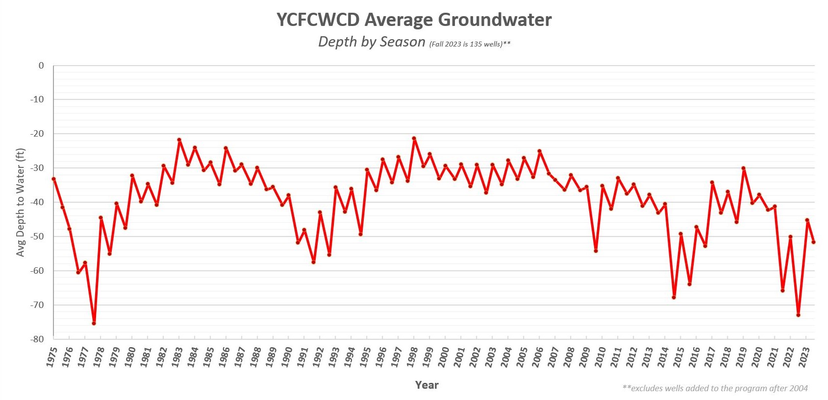
Fall Groundwater Levels
The District measured the depth to water for 135 wells throughout the District's groundwater monitoring network as part of our efforts to survey the health of the aquifer that many farms and communities rely upon. A graph has been compiled to illustrate the average depth to groundwater that can be accessed here.
Water Conditions: Current Lake Levels
For the most up-to-date information regarding water level information for Clear Lake and Indian Valley Reservoir, please access the links below to the USGS website. The information is updated hourly.
Historical Levels for Clear Lake
The link below to the USGS website displays a graph of the high and low lake elevations on Clear Lake for the past thirty years. Once on the USGS website, you can change the date to graph data going back to 1913.
Cache Creek Flows
The USGS monitors the level of water in Cache Creek at the bridge at several locations below Indian Valley and Cache Creek dams. Click the links below for the most current creek level observations, which will take you to the USGS website.
Public Records Request
Members of the public have a right to request to inspect and/or copy documents concerning the conduct of the District's business. According to the California Public Records Act, records shall be made promptly available for inspection. To request documents not normally made available to the public, please fill out the request form below and submit it to the District office.
Public Records Request Form
|


